GeoTriples

Publishing Geospatial Data as Linked Data

This work has been funded by the the FP7 projects LEO, MELODIES and Copernicus App Lab.
You can now download and install the KR-Suite that comes with Strabon, GeoTriples and Sextant in a single Docker.

About GeoTriples

Goal

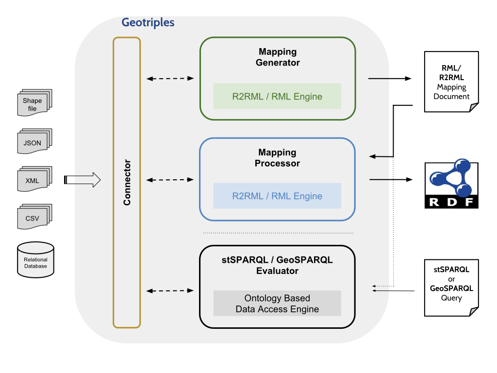
GeoTriples is a tool for transforming geospatial data from their original formats (e.g., shapefiles or spatially-enabled relational databases) into RDF. The following input formats are supported: spatially-enabled relational databases (PostGIS and MonetDB), ESRI shapefiles and XML, GML, KML, JSON, GeoJSON and CSV documents.

Support for R2RML and RML mappings

GeoTriples supports the mapping languages R2RML and RML and extends them for modeling the transformation of geospatial data into RDF graphs.

Architecture

GeoTriples comprises two main components: the mapping generator and the R2RML/RML mapping processor. The mapping generator takes as input a geospatial data source (e.g., a shapefile) and creates automatically an R2RML or RML mapping that can transform the input into an RDF graph which uses the GeoSPARQL vocabulary. The user may edit the generated R2RML/RML mapping document to comply with her requirements (e.g., use a vocabulary different than the one of GeoSPARQL). Then, the mapping processor executes the R2RML/RML mappings to produce the output geospatial RDF graph. The mapping processor of GeoTriples comes in two forms: a single-node implementation and an implementation that uses Apache Hadoop for dealing with big geospatial data. The second implementation can be found here.

It is often the case in applications that relevant geospatial data is stored in spatially-enabled relational databases (e.g., PostGIS) or files (e.g., shapefiles), and its owners do not want to explicitly transform it into linked data. For example, this might be because these data sources get frequently updated and/or are very large. If this is the case, GeoTriples is still very useful. GeoTriples users can use the generated mappings in the system Ontop-spatial to view their data sources virtually as linked data. Ontop-spatial is a geospatial Ontology-Based Data Access system which performs on-the-fly GeoSPARQL-to-SQL translation over spatially-enabled relational databases using ontologies and mappings.

The architecture of GeoTriples

Web Application

GeoTriples is also available as a web application.

The web application is the result of Despina Saptelianou's undergraduate thesis.

Publications


  • Kostis Kyzirakos, Ioannis Vlachopoulos, Dimitrianos Savva, Stefan Manegold and Manolis Koubarakis. GeoTriples: a Tool for Publishing Geospatial Data as RDF Graphs Using R2RML Mappings. Terra Cognita 2014, 6th International Workshop on the Foundations, Technologies and Applications of the Geospatial Web, in conjuction with ISWC 2014. Riva del Garda, Trentino, Italy, October 19-23, 2014. [pdf]


  • Kostis Kyzirakos, Ioannis Vlachopoulos, Dimitrianos Savva, Stefan Manegold and Manolis Koubarakis. GeoTriples: a Tool for Publishing Geospatial Data as RDF Graphs Using R2RML Mappings. In the Proceedings of the ISWC 2014 Posters & Demonstrations Track, pp 393-396. Riva del Garda, Trentino, Italy, October 21th, 2014. [pdf]


  • Kostis Kyzirakos, Dimitrianos Savva, Ioannis Vlachopoulos, Alexandros Vasileiou, Nikolaos Karalis, Manolis Koubarakis and Stefan Manegold. GeoTriples: Transforming Geospatial Data into RDF Graphs Using R2RML and RML Mappings. Web Semantics: Science, Services and Agents on the World Wide Web, 2018.[link]
  • Our Team


    National and Kapodistrian University
    of Athens, Greece

  • Ioannis Vlachopoulos (Developer)
  • Dimitrianos Savva (Developer)
  • Alexandros Vasiliou (Developer)
  • Despina Saptelianou (Web Application)
  • Nikolaos Karalis (Support)
  • Manolis Koubarakis (Supervisor)
  • Centrum Wiskunde & Informatica, Amsterdam, The Netherlands

  • Kostis Kyzirakos (Developer)
  • Stefan Manegold (Supervisor)
  • Contact Information

    Feel free to contact us at: nkaralis[at]di.uoa.gr or dimis[at]di.uoa.gr